
 Our reviews are 100% organic. We do not accept payment for reviews or bundle with advertising budgets. In most cases, the brand is providing the product to our reviewers free of charge.
 Basic summary: A two-way satellite tracking and communication device that is small and lightweight enough to conveniently carry on your long adventures. The Garmin inReach Mini allows two-way messaging from virtually anywhere in the world, using pre-set customized or real time message options. It also lets friends or loved ones track your progress in close to real time, and gives you the safety net of emergency response activation if necessary.
MSRP: $350, plus subscription package costs
Physical Specs and Features:
- Size: 2.04” x 3.90” x 1.03” (5.17 x 9.90 x 2.61cm)
- Weight: 3.5oz (100g)
- Display size: 0.9″ x 0.9″ (23 x 23mm)
- Display resolution: 128 x 128 pixels
- Battery: Rechargeable internal lithium ion
- Battery life:
- 35 hours at 10-minute tracking with 1-second logging
- 90 hours at 10-minute tracking (default)
- 24 days at 30-minute tracking power save mode
- Water rating IPX7
Communication and Connectivity:
- 2-way communication through global Iridium satellite network
- Interactive SOS capacity to 24/7 search and rescue monitoring center
- Accesses downloadable maps, U.S. NOAA charts, and color aerial imagery from Garmin Earthmate app
- Optional weather forecast service
- Send and receive messages through smartphone or compatible Garmin devices
- Send and receive text messages to recipient SMS and email
- Pre-set or customized free text message capability
- Track and share location with friends and family on web-based MapShare portal – progress map will overlay on planned route
 Deep dive:
The appeal of satellite communication devices is fairly obvious to anyone who has ventured outside the range of cell phones on an adventure run: it’s important to have a lifeline in case of emergency, and it’s reassuring to make contact with loved ones at home to let them know you’re still alive. Secondarily, it’s fun to share your progress in something close to real time for anyone interested in following along.
The “downsides” – we use the term loosely, because neither is sufficient justification to put yourself at risk – of using a satellite communicator have typically been size of the device and cost. Garmin’s inReach Mini resolves the size issue emphatically, and the company offers a compelling price strategy that will appeal to those who want to use the device sparingly while avoiding steep annual subscription fees.
Here are the basics you need to know about the inReach Mini: it’s a shrunken-down version of Garmin’s original inReach tracking device, which uses the Iridium global satellite system to allow communications literally anywhere in the world where you have clear access to the sky. It allows two-way pre-set or customized communication with emergency personnel or anyone you choose, and it works in conjunction with Garmin’s inReach website to provide route or tracking information to anyone you share it with. The device is extremely user friendly, and can be operated through your cellphone (even in airplane mode) for greater ease of use. Additionally, it is currently compatible with wrist operation on Garmin’s Fenix 5 devices, and the company has said this functionality will trickle down to the Forerunner 935 also, but there is no timetable announced for this yet.
Most of the operational capacity of the inReach Mini is done in advance of your adventure, using the Garmin inReach website. This is where you create your contact list, and decide whether they are contacted by text or e-mail (or both). You then set up the messages you will send from the trail, and which of your contacts they will be sent to. Customized messages fall into two categories:
- Pre-set messages. You have up to three pre-sets that can be customized up to 160 characters. You can send unlimited pre-set messages from the trail, regardless of which subscription plan you use.
- Quick text messages: This gives you a larger variety of message types to use, which allows for contingencies if your plans change, or just some fun communication. The number of these you can send or receive depends on which subscription plan you choose.

Customizable message options
The third type of messaging is the SOS function, which you’ll hopefully never have to use. If you do have to, it’s fairly easy: you pry off the protective hard plastic tab that prevents accidental activation, and press the button underneath to call in the cavalry.
Under the Map tab on the inReach website, you set up routes that can then be shared with your contacts as well as downloaded onto your device. You can choose from standard topo maps, Strava-style road/trail combo views, or aerial satellite views to figure out your route. If you’re going where absolutely nobody has ever ventured before (or at least, nobody with a GPS device), you can manually trace your route on these maps through an extremely slow and tricky drag-and-click process to create your own path – but in the vast majority of cases, you can find a GPX file of your intended route and quickly download it into the website. Our favorite source of established routes is the AllTrails app, but any GPX files will work. All of the maps and routes you create on the inReach website are transferred to the Garmin Earthmate app that is accessible on your phone when you’re on the trail.

Planned route created on website
The final variable you set from the website is how frequently you want your location logged and tracks uploaded for display. These variables affect the battery life of the device (see spec list above), and they will also rack up additional expenses, depending on what subscription plan you use.
After you create your route, you can share it with your contact list; each recipient will receive an e-mail or text with a link to your intended route – and when they are tracking your progress during your run, they’ll see your current location relative to the desired route. Access to your route is only available to those whom you send the invitation e-mail.

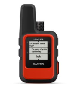
Blue dots track progress; messages show location of origin
Once you finally hit the trail, the inReach Mini is very user friendly to stow and operate. It comes with a carabiner clip to attach to your pack, but we found it more comfortable with less bouncing when stashed in one of the upper pouches. It should be carried at chest level or higher to more effectively send tracking pings. Button operation is fairly intuitive, with visual cues leading you into and out of menu options. When you’re ready to send a message, you choose between your pre-set or quick text options, and fire away; the device beeps once your message is successfully sent, and chirps if you receive an incoming message.
In our testing, sending messages worked very effectively, but not always quickly. Garmin’s instructions say you only need a view of the sky for the antenna to lock into the satellite network and send messages promptly, but we found that the opening to the sky needs to be fairly expansive. In moderate tree cover or minor canyons, there’s a noticeable delay – up to a few minutes or more – between pushing “send” and getting the confirmation beep that it was actually sent.
As for the subscription costs, Garmin offers four different options to choose from, which vary mainly in the number of messages that can be sent, but also in some of the features that are available. Each plan has an annual program fee, and either a 12-month contract price or per-month Freedom price structure. One attractive option is the Safety plan, which is perfect for those who only have need for this kind of device on a seasonal or otherwise periodic basis. The annual program fee is $25, and the monthly Freedom price is $15 – so if you only need a satellite device for a few summertime adventures, your total cost for safety and peace of mind is very manageable.

Four subscription packages to choose from
The Freedom plan is more expensive per month than the annual contract plan, but it allows you to suspend the service at times. Let’s say you’ve already paid the annual program fee and taken a couple of adventures, but don’t have anything planned for four more months; with the Freedom pricing, you only pay activation fees for the months you use the device, and not all the months in between. Note that the Safety plan still charges 10 cents per tracking points and location pings, which can add up if you’re racking up a lot of miles on your bargain subscription plan. If you’re doing a multi-day trek or making multiple outings per year that require satellite communication or tracking, one of the higher-level subscriptions might be more appropriate.
The Garmin inReach Mini is available at www.buy.garmin.com as well as numerous retailers and online.
2 comments
Thanks for this informative review. I have been looking at this or the full size version for use in Asia. I dabble in ultras, but my primary need is for use in disaster response work throughout Asia. I would like to have a reliable method of communication in remote areas or where cell phone system has been damaged. I like the Freedom Plan, where I could only activate it the months I need it. Satellite phone plans don’t offer that option. I know in different regions of the world, different Satphone systems are in place. In Asia, Irridium works well. While Garmin claims this will work nearly anywhere in the world, I would be very interested to hear if someone has real-world experience using this device in Asia – from Nepal to Borneo?
Garmin uses the Iridium network for the inReach. Because this is longitudinal orbit (unlike the SPOT/Globestar geosynchronous orbit) it works the same everywhere in the world you have a clear view of the sky – including Asia.
Comments are closed.